- Home - News
- TWI News | TV
- Polls
- Year In Review
- News Archive
- Crime & Punishment
- Politics
- Regional
- Editorial
- Health
- Ghanaians Abroad
- Tabloid
- Africa
- Religion
- Election 2020
- Coronavirus
- News Videos | TV
- Photo Archives
- News Headlines
- Press Release
General News of Monday, 24 June 2013
Source: Kofi Akpabli
COMMENT: A Stroll in old Accra
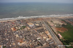
The Atlantic kisses its entire length. As the ocean water splashes its shores, the sands of this place are soaked in history. A walk through Old Accra reveals the new and the very, very old. Every few steps are saturated with landmarks that ooze with stories; stories which have helped to define our dear nation, Ghana.
Yes, there are remnants of colonial structures; but at first sight some parts look like an ordinary neighbourhood. Indeed, when one drives past it would be hard to imagine that five centuries of solid heritage are squeezed between the alleys, broken walls and box-like homes.
Old Accra can be defined as starting from Victoriaburg (Victoriaburg Press is no longer there now) or the traffic-light junction of CEPS Head Office, through the stretch of the High Street toward the Korle Lagoon area. It includes what used to be called British Accra to the west (James Town area) and Dutch Accra to the east (Ussher Fort area). Old Accra also includes the iconic community called Bukom.
A fascinating history of migration, chieftaincy, slavery and colonialism has combined to bequeath a mixed society. When one visits, one cannot help but be an eyewitness to how windingly-connected the people are to other parts of Ghana, and the world at large. When Europeans arrived in the 16th century, they turned Old Accra into a trading centre for fish, gold, guns and other goods. Today, the place is the vestige of a colonial order and an ancient Ga world.
Oh, there is also a whiff of good old human toughness in the air! Here in Ga Mashie, people say it as it is -- and if necessary slug it out on the punch. There is something else that shouldn’t be -- poverty. But that is another story; for now, let’s hit the road.
At seven in the morning, I stood under the entrance-shed of Shell Head Office, waiting to explore. Toward the west, I could see Sam Nii Badoo had just arrived in his van. He steps out in front of Ussher Fort. Nii Badoo is the one who will hold my hand, walk me through the alleys and point out things of interest. A tour-guide with 26 years experience, Nii has trained twelve community guides for old Accra.
My tour guide has had to manoeuvre the Tema motorway to be here for the appointment. Much as we were on time, the June rain had other ideas. It had been drizzling since I arrived on this side of High Street. The knapsack on my back had already taken some beating, though my cap ensured my hair was dry. The situation was not good for my camera and notepad: they remained bagged. Nii Badoo wanted to know if we should wait for the rain to quieten down. No way, let’s do it.
The walk took three hours. But having seen what I saw, I think it should be for three days. One quick thing I learnt is that some of the folklore we heard while we were schoolkids have a historical basis. If you know or remember the Ga song ‘Mele nii ya eey damoshi mashe bo’, it is history set in a lullaby. At one time during the colonial era, Mantse Tackie Tawia I was found by the British, to be too much to handle. They put the king in a ship (mele) and exiled him to Elmina.
The real Accra is called Ga Mashie. When translated this sounds like “Ga state is standing or alert”. Well, not quite. There’s a little story you might like: it is said that a group of Ga's were in such a hurry to leave their last place of settlement, called Grand Popo in today’s Benin. Result? Well, they forgot to bring along their corn-dough prepared for meals on arrival. This prompted part of the retinue to tease the chief and his family as ‘Ga mma shiloi’ to wit, ‘The Gas who left their corn-dough behind’’
Over centuries, it became corrupted to ‘Ga Mashie’. The Ga Mashie boundaries at the time covered the Volta River area in the east to the Lanma Hill site on the west near Kokrobite. Accra today is made up of seven communities or towns which emerged from older ones or were settled from other places. These communities are: Abola, Asere, Gbese, Otublohum, Sempe, Akamnadzen and Ngleshie Alata.
Our tour into the heart of Accra took off at Ussher Fort. It was built by the Dutch in 1649 and famously referred to as Fort Crèvecœur. If you think the name sounds French, c’est vrai. It is because, at a point, the French seized the Fort, renamed it and gave it back. Comme ca.
We went through to the back and faced the sea. The native name of the place is Abra Nshonaa. Oral accounts have it that the Ga people disembarked at this place under the leadership of one Borkete Larweh. Larweh wielded both political and religious power. They arrived with two shrines, the Sakumo and Chemu, which are today cherished as the earliest monuments in Ga history.
A look at the shoreline to the east shows that this is strategically a high point. On our right, against a hazy horizon scores of fishing boats could be seen floating on the calm sea. Also, visible from the distance is the old Accra Harbour.
Moving the harbour from Accra to Tema in 1962 has had an adverse impact on the local economy of Ga Mashie. From here we saw what remains. The break-water and gully fork into the sea consoling each other over the days of glory which are forever gone.


