The Volta Regional Spatial Planning Committee has begun gathering data from key government institutions to develop a 20-year Spatial Development Framework (SDF) to guide land use, infrastructure development and environmental protection across the region.
The framework is expected to provide a coordinated approach to development by integrating land use, settlement patterns, road networks, agriculture, education, healthcare and other essential services.
Benjamin Mensah, the Volta Regional Director of the Land Use and Spatial Planning Authority (LUSPA) and Secretary of the Regional Spatial Planning Committee, disclosed this during a three-day technical working session involving key government institutions.
He said the framework would help harmonise development activities and ensure that decisions on infrastructure, social services and natural resources were guided by a common long-term plan.
“Any form of development has its manifestation in space. The framework is supposed to guide how we develop our region, and it is valid for 20 years,” he said.
Mensah explained that the initiative was being undertaken in accordance with the Land Use and Spatial Planning Act, 2016 (Act 925), which requires regional spatial planning committees to prepare development frameworks for their respective regions.
He said this was the first time the Volta Region was undertaking the exercise, adding that the involvement of relevant institutions would improve access to data and strengthen the quality of the final document.
Institutions responsible for water, feeder roads and highways, among other sectors, are contributing information on existing infrastructure and development conditions to inform the planning process.
Mensah said the committee had decided to collaborate directly with relevant institutions in the region after encountering difficulties obtaining some of the required information.
He said the framework would help protect the region’s forests, rivers and other natural resources by incorporating environmental conservation measures and buffer zones around water bodies.
He added that proper spatial planning could help prevent haphazard development, congestion and encroachment on environmentally sensitive areas.
Mensah, however, stressed that the framework’s success would depend on effective implementation through lower-level planning instruments, including structure plans and local plans.
He called on government institutions to provide the necessary data to enable the committee to develop a comprehensive framework to guide the region’s development over the next two decades.
Regional News of Tuesday, 27 October 2026
Source: Desmond Tinana, Contributor
Volta Region begins work on 20-year spatial development framework
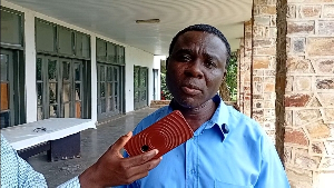 Mr Benjamin Mensah, Volta Regional Director for Land Use and Spatial Planning Authority (LUPSA)