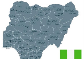
Nigeria is divided into 36 states and one federal capital territory, which, in turn, are divided into 774 local government areas.
Evans Osabuohien, an Economics Professor at Covenant University, provides insights on how these states can contribute to Nigeria's economic significance, fostering inclusive growth and sustainable development.
Nigeria is a vast country in terms of both area and people. With a population of almost 200 million people, it is Africa's most populous country. The following are the 10 biggest states in Nigeria that you should be aware of.
Here are a list of Nigeria's top 10 largest states and top facts about each of them.
Top 10 largest states in Nigeria
Here is a list of the top ten largest Nigerian states, from smallest to largest.
10. Kebbi State - 36,800 km²
Date created: 27 August 1991
Capital: Birnin Kebbi
Total area: 36,800 km²
Kebbi State is bordered by Sokoto State, Niger State, Zamfara State, Dosso Region in the Republic of Niger and the nation of Benin. It has 21 Local Government Areas.
They include: Aleiro, Arewa Dandi, Argungu, Augie, Bagudo, Birnin Kebbi, Bunza, Dandi, Fakai, Gwandu, Jega, Kalgo, Koko/Besse, Maiyama, Ngaski, Sakaba, Shanga, Suru, Danko/Wasagu, Yauri, Zuru.
Kebbi is the tenth largest state in the region and the 22nd most populous, with an estimated population of 4.4 million people in 2016. It is known as the "Equity Land."
9. Kwara State - 36,825 km²
Date created: 27 May 1967
Capital: Ilorin
Total area: 36,825 km²
Kwara is located within the North Central geopolitical zone, commonly referred to as the Middle Belt. It has 16 Local Government Areas. They include Asa, Baruten, Edu, Ekiti, Ifelodun, Ilorin East, Ilorin South, Ilorin West, Irepodun, Isin, Kaiama, Moro, Offa, Oke Ero, Oyun, and Pategi.
Kwara is the sixth-least populous state, with an estimated population of 3.2 million people in 2016.
Geographically, it is divided into two ecoregions: the West Sudanian savanna to the east and the Guinean forest-savanna mosaic ecoregion to the west.
8. Adamawa State - 36,917 km²
Date created: 27 August 1991
Capital: Yola
Total area: 36,917 km²
The Borno borders Adamawa State on the northwest, Gombe on the west, and Taraba on the southwest. Its eastern border forms the national eastern border with Cameroon. It has 21 Local Government Areas.
They include: Demsa, Fufore, Ganye, Girei, Gombi, Guyuk, Hong, Jada, Lamurde, Madagali, Maiha, Mayo-Belwa, Michika, Mubi North, Mubi South, Numan, Shelleng, Song, Toungo, Yola North, and Yola South.
Adamawa is the thirteenth least populated in population, with an estimated 4.25 million residents as of 2016. It also has a diverse religious community, with roughly 55% Sunni Muslims, 30% Christians, and 15% followers of traditional ethnic religions.
7. Zamfara State - 39,762 km²
Date created: 1 October 1996
Capital: Gusau
Total area: 39,762 km²
Zamfara is a state in northwestern Nigeria with a predominantly Hausa and Fulani population. It has fourteen Local Government Areas.
They include: Anka, Bakura, Birnin Magaji/Kiyaw, Bukkuyum, Bungudu, Tsafe, Gummi, Gusau, Kaura Namoda, Maradun, Maru, Shinkafi, Talata Mafara, and Zurmi.
It has a population of 9,278,873, according to the 2006 census.
The state's primary industries and main sources of revenue are agriculture and gold mining. More than 80% of the population works in agriculture.
6. Yobe State - 45,502 km²
Date created: 27 August 1991
Capital: Damaturu
Total area: 45,502 km² Yobe State borders four states: Bauchi, Borno, Gombe, and Jigawa State.
In addition, it borders the Diffa Region and the Zinder Region to the north of the Republic of Niger.
It has seventeen Local Government Areas. They include: Bade, Bursari, Damaturu, Geidam, Gujba, Gulani, Fika, Fune, Jakusko, Karasuwa, Machina, Nangere, Nguru, Potiskum, Tarmuwa, Yunusari, and Yusufari. Yobe is a state that is both rich in mineral reserves like gypsum and kaolin and is also an agricultural state.
Groundnuts, beans, cotton, gum arabic, and gum arabic are among the state's agricultural products.
5. Bauchi State - 45,893 km²
Date created: 3 February 1976
Capital: Bauchi
Total area: 45,893 km²
The state is bordered by seven states: Kano and Jigawa on the north, Taraba and Plateau on the south, Gombe and Yobe on the east, and Kaduna on the west. It has twenty Local Government Areas.
They include: Bauchi, Tafawa Balewa, Dass, Toro, Bogoro, Ningi, Warji, Ganjuwa, Kirfi, Alkaleri, Darazo, Misau, Giade, Shira, Jama'are, Katagum, Itas/Gadau, Zaki, Gamawa, and Damban.
According to 2016 estimates, the population of Bauchi State was over 6,530,000, making it the ninth most populous country. Livestock and crops like tomatoes, yams, cotton, groundnuts, and millet are a part of its economy.
4. Kaduna State - 46,053 km²
Date created: 27 May 1967
Capital: Kaduna
Total area: 46,053 km² Kaduna State is a state in northern Nigeria.
It is the third most populous state in the country, with numerous educational institutions of importance, such as Ahmadu Bello University. It has twenty-three Local Government Areas.
They include: Birnin Gwari, Chikun, Giwa, Igabi, Ikara, Jaba, Jema'a, Kachia, Kaduna North, Kaduna South, Kagarko, Kajuru, Kaura, Kauru, Kubau, Kudan, Lere, Makarfi, Sabon Gari, Sanga, Soba, Zangon Kataf, and Zaria.
3. Taraba State - 54,473 km²
Date created: 27 August 1991
Capital: Jalingo
Total area: 54,473 km² Taraba State is bordered in the west by Nasarawa State and Benue State, in the northwest by Plateau State, in the north by Bauchi State and Gombe State, in the northeast by Adamawa State, in the east and south by Cameroon.
It has sixteen Local Government Areas. They include: Ardo Kola, Bali, Donga, Gashaka, Gassol, Ibi, Jalingo, Karim Lamido, Kurmi, Lau, Sardauna, Takum, Ussa, Wukari, Yorro, and Zing.
2. Borno State - 70,898 km²
Date created: 3 February 1976
Capital: Maiduguri
Total area: 70,898 km²
Borno is the second biggest state in Nigeria. It has twenty-seven Local Government Areas.
They include: Maiduguri, Ngala, Kala/Balge, Mafa, Konduga, Bama, Jere, Dikwa, Askira/Uba, Bayo, Biu, Chibok, Damboa, Gwoza, Hawul, Kwaya Kusar, Shani, Abadam, Gubio, Guzamala, Kaga, Kukawa, Magumeri, Marte, Mobbar, Monguno, and Nganzai.
As of 2016, the state's population was predicted to be 5.86 million, making it the ninth most populated state. In Borno State, many people practise Islam, and an equal number practise Christianity and other religions.
1. Niger State - 76,363 km²
Date created: 3 February 1976
Capital: Minna
Total area: 76,363 km²
Which state is the largest state in Nigeria? Niger is the largest state in the country. It is located in the country's north-central area and has three political zones: A, B and C.
It has twenty-five Local Government Areas. They include Agaie, Agwara, Bida, Borgu, Bosso, Chanchaga, Edati, Gbako, Gurara, Katcha, Kontagora, Lapai, Lavun, Magama, Mariga, Mashegu, Mokwa, Munya, Paikoro, Rafi, Rijau, Shiroro, Suleja, Tafa, and Wushishi.
During a discussion with Evans Osabuohien, an Economics Professor at Covenant University and a seasoned researcher, he emphasised that effectively channeling land, as an economic resource, into productive use is crucial for ensuring the prosperity of the state.
A state with a large landmass does not determine if it will be more economically productive than others (those with a small landmass), for example, Lagos State is the smallest in the country, yet it has the largest economic prowess. If you look at the top ten largest states by landmass in Nigeria, not many of them are among the top ten states in terms of GDP (gross domestic product) or economic prowess or empowerment.
Africa News of Saturday, 23 December 2023
Source: mynigeria.com


